Introduction
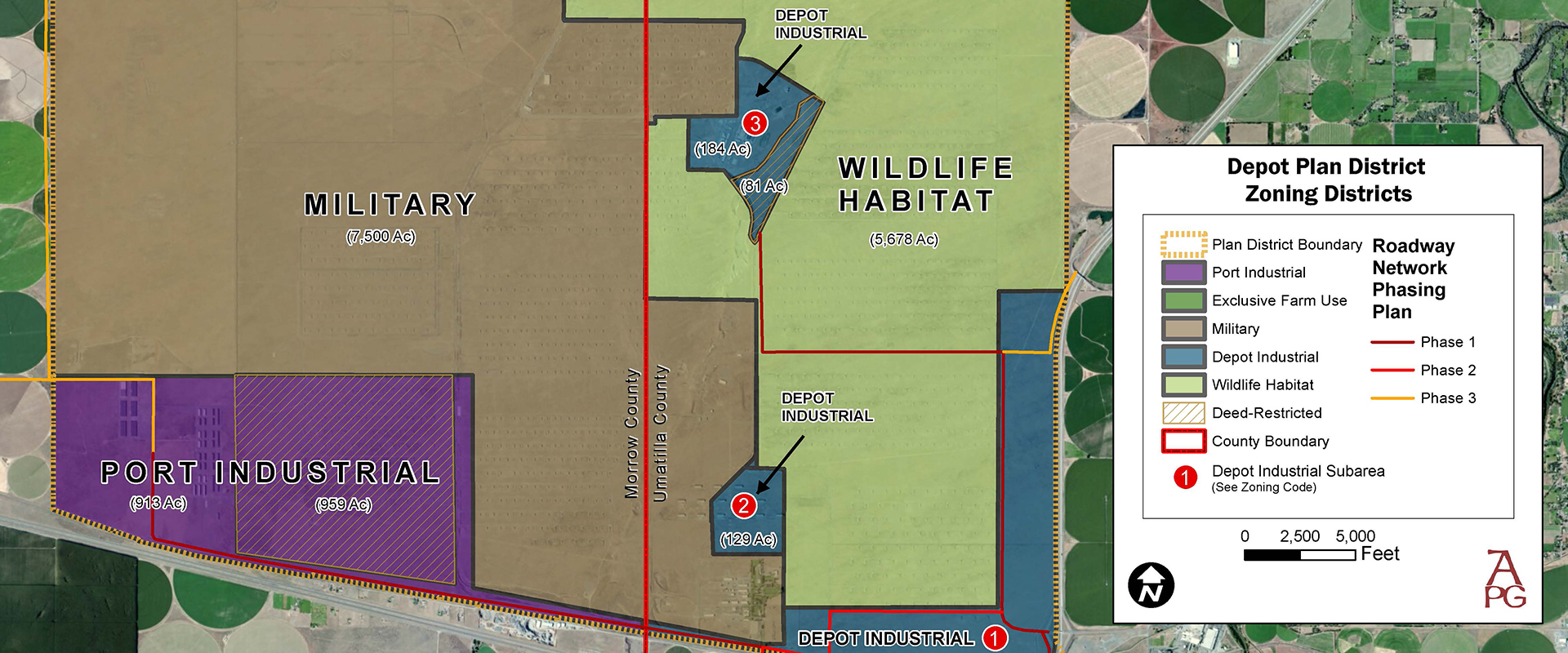
The Umatilla Army Depot located in Northeastern Oregon underwent closure in 2012. Redevelopment planning for the former 17,000-acre munitions storage and shipment facility is now well advanced, and 3,100 acres are designated for industrial zoning and development. The former base is a unique facility that offers several advantages for certain types of industrial applications. Transportation linkages at a key West Coast crossroads are outstanding including highway, rail, and water-based port facilities. The property is located approximately 45 miles west of the Umatilla Confederated Tribes Indian Reservation (CTUIR). Given the proximity to the reservation, and CTUIR being part owners of the property, industrial applications are given a unique employment opportunity.
The location is only one of seven sites in Oregon that is at the junction of two Interstates, and the only one of those seven sites located on the “eastside” outside of urban congestion and sheltered from potential surrounding land use conflicts. Moreover, the Umatilla Depot offers large parcel sizes that are difficult to secure in other locations at reasonable cost. The location is an energy hub for the Pacific Northwest and the site offers both low-cost electric and natural gas.
Ownership Structure
Redevelopment planning at the former Umatilla Army Depot has been undertaken by the Columbia Development Authority (CDA). The CDA is comprised of five cooperating members: The Port of Morrow, Port of Umatilla, Confederated Tribes of the Umatilla Indian Reservation, and the counties of Morrow and Umatilla. All five members have a strong commitment to industrial reuse and bring to the table a track record of cooperation and substantial capacity in economic development.
Location and Workforce
Located in the southern portion of the Columbia Basin, the land is 4 miles from the Columbia River in Northeastern Oregon and 4 miles from the Washington State border at the intersection of I-84 and I-82. Surrounding small cities include Hermiston, Irrigon, Umatilla, and Pendleton and Morrow County with an approximate population of 90,000. Thirty-nine miles to the north is the Washington state urban complex of Tri-Cities, Washington and surrounding area with a population base of over 830,000. Tri-Cities, Washington is a center for energy research including the Northwest National Laboratory and Hanford Nuclear Reservation.
Area employers’ benefit from a trained and educated workforce originating both locally and from the Tri-Cities, WA complex. The Port of Morrow’s main complex is located 7 miles to the west of the base and currently contains over 50 manufacturers with a combined workforce of over 6,000 employees. The Confederated Tribes of the Umatilla Indian Reservation and Port of Umatilla also offer impressive industrial support capabilities, each that is unique.
Education for the workforce:
The Blue Mountain Community College system has partnered with the two port districts and regional employers to provide on-going customized training programs. Blue Mountain Community College is located in Pendleton, Boardman and in Hermiston. Hermiston is home to Eastern Oregon University satellite school in conjunction with Blue Mountain Community College. Additionally, there are four other colleges within forty-five miles of the area: Washington State University (Richland campus), Columbia Basin Community College, Whitman College in Walla Walla and Walla Walla Community College.
Transportation Links
The sites are served by two dedicated Interstate interchanges that are strategically located at the intersection of I-84 and I-82. Both interchanges serve exclusively the base. There is no congestion of any type and Industrial development of the parcel(s) would be the only future source of traffic at the Westland Road interchange, which is the primary access point for the Umatilla County sites. The junction of I-84 and I-82 is a key nexus point in the Pacific Northwest interstate system, providing access to Seattle and the British Columbia market to the north, Portland and northern California to the west, and Boise and Salt Lake City to the east and south.
Union Pacific’s main-line parallels the south side of I-84 (the Depot) and a former spur line served the entire south boundary of the Depot. A rail car classification and storage yard also exist in the southwest portion of the base; however, improvements will be necessary to reestablish full functionality.
The Port of Morrow and Port of Umatilla both maintain extensive water port facilities on the Columbia River seven and five miles respectively from the base. The facilities include docks, berths, overhead cranes and container facilities. The port facilities provide crucial transportation links to the Pacific Ocean and international markets that are actively used by area industries.
NOTE: Infrastructure is not currently built, as we are currently working with our engineer and the county planner on a masterplan development for infrastructure.
Utilities
The CDA property is within proximity to water, wastewater, gas, and electricity.
